Sheri Wysong, The Mountain Men, the Cartographers, and the Lakes.
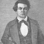
Sarah Vowell discusses the life of the dour Charles Preuss, "The Homesick Explorer."
Several of the maps analyzed by Sheri Wysong in “The Mountain Men, the Cartographers, and the Lake” (UHQ, Spring 2018) are available in high resolution online:
- David H. Burr, The American Atlas, 1839, Library of Congress
- David H. Burr, North-west-Coast of North America and adjacent Territories …, 1840, University of Washington Digital Collections
- David H. Burr, Map of the United States of North America, 1842, David Rumsey Map Collection
- David H. Burr, The State of Texas, 1836–1845, 1845, Yale University Library Digital Collections
- John C. Frémont, Map of an exploring expedition to the Rocky Mountains …, 1845, Library of Congress
- David H. Burr, Map of the United States, 1854, David Rumsey Map Collection
- J. H. Colton, Territories of New Mexico and Utah, 1856, David Rumsey Map Collection
- George W. Colton, California, Nevada, Utah, Colorado, Arizona and New Mexico, 1865, David Rumsey Map Collection
- Hubert Howe Bancroft and W. H. Knight, Bancroft’s Map of the Pacific States, 1867, David Rumsey Map Collection
- George W. Colton, California, Nevada, Utah, Colorado, Arizona and New Mexico, 1869, David Rumsey Map Collection
- Samuel A. Mitchell and W. Williams, Map of the United States and territories …, 1870, David Rumsey Map Collection
- George M. Wheeler, 58. Parts of Eastern and Southern Nevada and Southwestern Utah, 1872, David Rumsey Map Collection
- George M. Wheeler, 59. Southwestern Utah, 1873, David Rumsey Map Collection
- Asher and Adams, Utah, 1874, David Rumsey Map Collection
- B.A.M. Froiseth, Froiseth’s New Sectional and Mineral Map of Utah, 1878, Utah State Historical Society
- U.S. War Department, Map of California and Nevada, with Parts of Utah and Arizona, 1879, David Rumsey Map Collection
- Joseph A. West, West’s New Sectional and Topographical Map of Utah, 1885, David Rumsey Map Collection
- George W. Colton, Wyoming, Colorado and Utah,1886, David Rumsey Map Collection
- Mosiah Hall, Charles Wright, and Don Maguire, Relief Map of Utah, 1895, Library of Congress